Pagosa Gateway Project
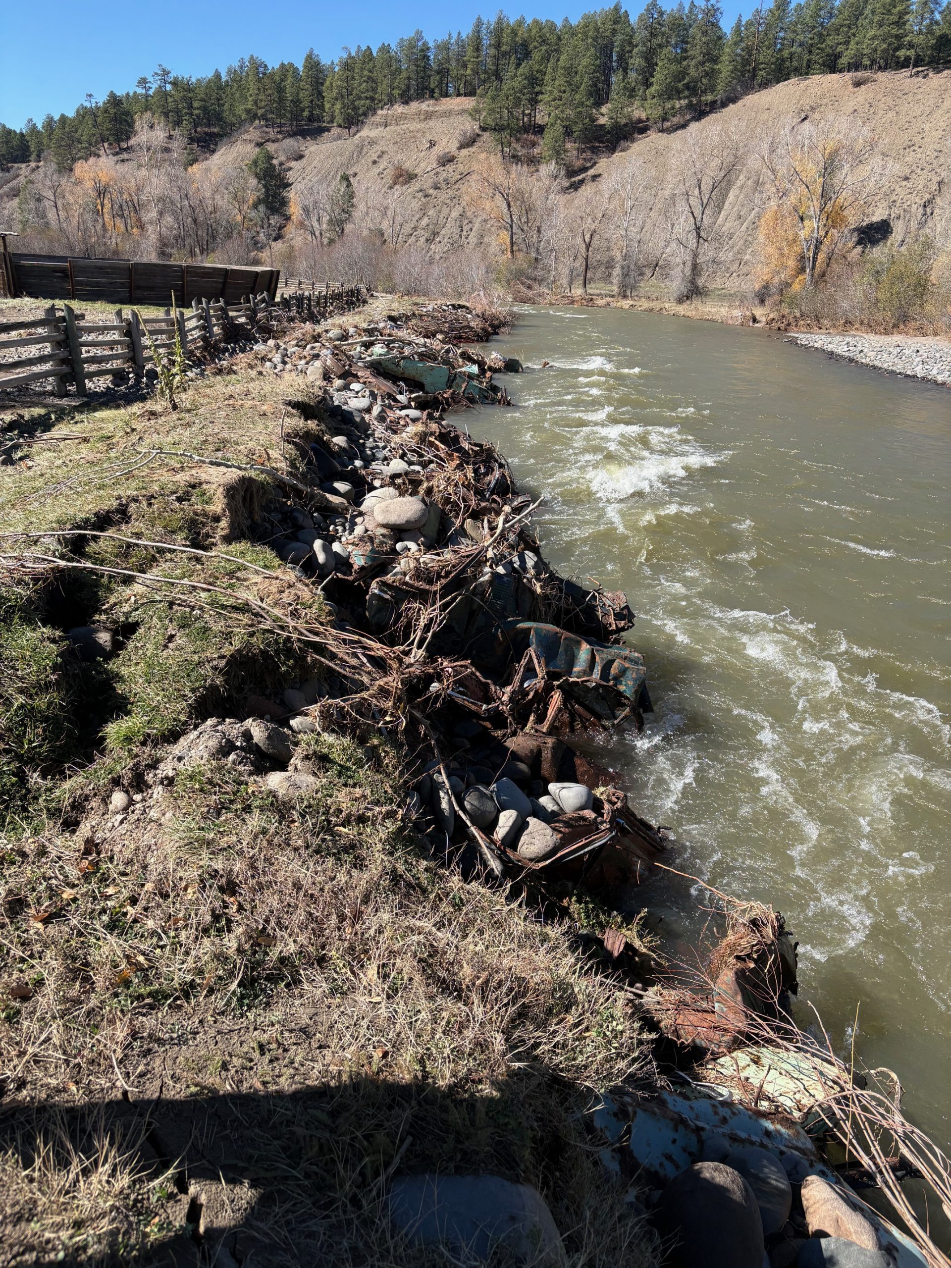
The Pagosa Gateway Project was a vital restoration endeavor targeting approximately 2 miles of the San Juan River upstream of the town of Pagosa Springs. This project aimed to strengthen aquatic habitat and enrich recreational opportunities amid challenges posed by dwindling water flows and escalating stream temperatures.
Interested in financing more projects like this?
All about the Pagosa Gateway Project
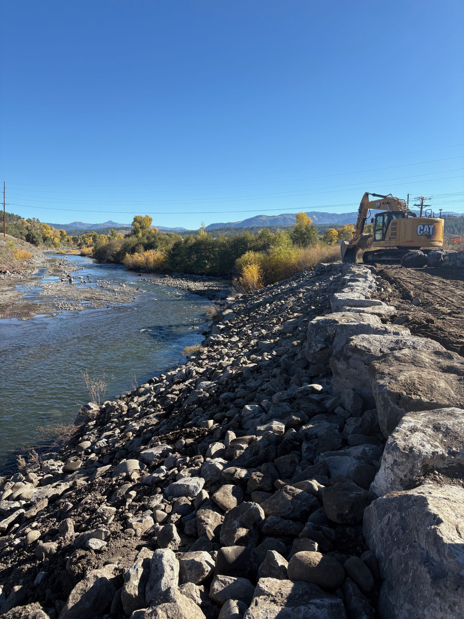
The Project was overseen by the Upper San Juan Watershed Enhancement Partnership (WEP), a Pagosa Springs non-profit organization. In early 2024 WEP conducted a rigorous procurement process and selected FlyWater, Inc to design, permit and build the project. Construction of the project is expected to be completed by late 2025. The project consists of a series of river corridor improvements, including channel enhancements, riparian area revitalization, habitat improvements tailored to support the local fishery, and stream bank protection. To the extent possible, streambank features that currently pose a risk to boaters and other river users will attempt to be minimized.
The collaboration of 18 dedicated landowners amplifies the project’s impact, ensuring benefits extend both upstream and downstream of the project area. By enhancing stream connectivity, diversifying habitats, and bolstering the river’s resilience to drought and low-flow conditions, the project aims to foster healthy fish populations and riparian habitat throughout the region.
A total of $1.5M has been awarded for this transformative project, primarily from the Colorado Water Conservation Board (CWCB) Water Plan Grant Program and the Bureau of Reclamation’s WaterSMART Grant Program. Additionally, the Town of Pagosa Springs, Pagosa Springs Area Tourism Board (lodging tax funds), Southwestern Water Conservation District, The Nature Conservancy, San Juan Water Conservancy District, Trout Unlimited, and Friends of the Upper San Juan have contributed as local funding partners.
Expected Benefits from this Project
- Strengthens river’s resiliency for improved ecological health and recreation.
- Safeguards aquatic habitats and recreational opportunities in the face of changing climate conditions.
- Addresses hydrological shifts impacting aquatic and riparian life and recreational activities, including the creation of low flow channels to allow greater connectivity during late summer low flow periods.
- Establishes riffle and pool habitats to benefit native and recreational fish populations.
- Reestablishes riparian vegetation to provide shade and therefore reduce summertime stream temperature.
- Reinforces river banks by promoting native vegetation to mitigate erosion.
- To the extent feasible, minimizes streambank hazards, enhancing safety for recreation.
- Supports Pagosa Springs’ tourism-based economy linked to the river’s well-being.
- Enhances the aesthetic, ecological and recreational values of the San Juan River.
Project Photos • Before & After
Pagosa Gateway FAQs
What was the purpose of the Pagosa Gateway Project?
The project is designed to improve the health and function of the San Juan River upstream of Pagosa Springs. Goals include:
- Enhancing in-channel aquatic habitat via increased hydraulic cover, low water connectivity, and increasing pool depth.
- Stabilizing eroding riverbanks.
- Removing hazardous debris and improving boater safety.
- Restoring native riparian vegetation and improving riverbank resilience.
This work addresses challenges from changing climate conditions, increased recreational use, and legacy modifications to the river channel.
Who are the sponsors of the Project?
- Upper San Juan Watershed Enhancement Partnership (WEP)
- The Town of Pagosa Springs
- San Juan Water Conservancy District
- Pagosa Springs Area Tourism Board
- Friends of the Upper San Juan River
- Southwestern Water Conservation District
- Trout Unlimited
- The Nature Conservancy
- Colorado Water Conservation Board
- Bureau of Reclamation
Where is the project located?
The project covers a 2-mile stretch of the San Juan River upstream of the Town of Pagosa Springs (starting at the Hwy 84/Hwy 160 intersection and proceeding upstream), along areas of mixed residential and commercial land use.
Why was restoration needed?
This river reach has limited habitat diversity, unstable and eroding banks, debris from past flood events, and impaired riparian areas. Restoration will:
- Improve fish habitat and low-water connectivity.
- Reduce sediment input from eroding banks.
- Provide safer conditions for recreational users.
- Support long-term river health and resilience.
When did construction occur?
Construction is scheduled to begin in September 2025 and is expected to take approximately 2.5 months, finished by 2025. Work is planned to occur on weekends during this project. Construction sequencing in various areas of the project reach have been established to minimize disruptions to private land use. If river levels or weather delay work, activities and revegetation may continue into spring 2026.
Was the river closed during construction?
Some short-term closures may be needed for safety when work is occurring in or near the river.
What equipment was used?
Construction will use excavators and specialized carriers to move rock and materials. Access routes will use existing roads and temporary ramps that will be fully restored after construction.
How was noise and dust managed?
Construction activities will generate typical construction noise during daytime hours. Dust control measures (such as watering disturbed areas) will be implemented as needed. Work will comply with all local ordinances regarding noise and air quality.
Was there increased truck traffic?
Material deliveries, including boulders and riprap, will increase truck traffic temporarily. Truck routes will use existing roads, and staging areas are designed to minimize impacts on nearby properties.
How did project affect property access?
No permanent changes to private property access are expected. Temporary access ramps may be built for construction equipment but will be removed and fully restored when work is completed.
How were fish and wildlife protected?
- Seasonal restrictions are in place to avoid sensitive wildlife periods.
- Bank stabilization and revegetation will improve habitat over the long term.
- Increased turbidity is expected periodically during the project. If levels become problematic to aquatic species, alternate construction methods and live water diversions may be employed.
Were wetlands or water quality affected?
No permanent wetland impacts are expected. Temporary disturbance areas will be restored and erosion controls will be installed. No permanent impacts to water quality are expected. Temporary impacts to water quality will be periodic increased turbidity.
How was vegetation restored?
Native plants and seed mixes will be used for revegetation along with locally harvested native plants.
How was success measured?
Monitoring will occur for at least five years after construction and includes:
- Fish population and species diversity surveys.
- Riparian vegetation health assessments.
- Physical stability checks on bank protection features.
Who will maintain the improvements?
Long-term stewardship will be coordinated by the project sponsors. If changes occur that require maintenance, appropriate measures will be taken to keep the river functioning as intended per the design.
Want to support future projects like this?
Thanks to our financial donors, we were able to make this project a success! If you want to get involved financially and help support future projects like this one, click “donate here” below to get started.